Mallorca map update
Municipal boundaries and terrain view.
Since the initial presentation in October, BalearWeb has improved and added new resources to the Google Maps mashups for Mallorca, Menorca, Ibiza and Formentera.
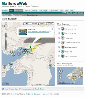
One of the recent improvements is a new layer that shows the municipal boundaries of each island, except in Formentera, where the parish boundaries are displayed. The division is used not only to show the administrative boundaries of each municipality, but also to surf from one municipality to another without having to go back to the Island map each time.
Another new feature is the "Terrain" view, that complements the "Map", "Satellite" and "Hybrid" views. The "Terrain" view represents the relief of mountains and other landforms through shadows and colours, being quite interesting in the mountainous areas of the archipelago.
As for the introduction of data, in the Map of Mallorca the municipalities that are almost complete are Andratx with 85 resources including pictures and exhibition sites, Ariany with 11, Banyalbufar with 16, Campos with 38, Costitx with 12, Deià with 46, Estellencs with 20, Lloseta with 8, Maria de la Salut with 6 and Petra with 24.
On the other hand, the Map of Menorca groups at the moment 194 resources, the Map of Ibiza 185 and the Map of Formentera 72.
More over the information is available in KML format via files that can be viewed with the desktop application Google Earth.
© 1996-2024 BalearWeb / Mallorca - Advertising - Contact - Legal note - Accessibility