From s'Almunia to Cap de ses Salines
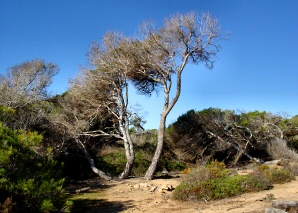


The extreme south of Mallorca, surrounded by the Migjorn Marine Reserve, preserves one of the most extensive, non developed coastal areas of the island. The whole coast from Cala s'Almunia as far as the Colònia de Sant Jordi remains virgin, comprising one of the most attractive natural areas of Mallorca for walkers and nature lovers.
Both the route from Cala s'Almunia to Cap de ses Salines, which is described below, and the one from the Cap de ses Salines to the Colònia de Sant Jordi, described in another article, have inimitable scenery.
The path from Cala s'Almunia to Cap de ses Salines is 8 kilometres long. This can be covered in some three hours, plus resting time, and does not present great difficulties. The itinerary passes mainly through areas of cliffs, in contrast to that of the Cap de ses Salines to the Colònia de Sant Jordi, where sandy areas predominate.
At the beginning of the excursion the first point of interest is the Caló des Moro, a lovely unspoilt sandy beach surrounded by cliffs, just behind Cala s'Almunia. Following on Cala s'Almunia is to be found, a picturesque cove of great beauty with a few humble fishermen's huts.
Continuing along the coast, towards the southwest and following the signs that show the way, you soon reach the prehistoric village Ses Talaies des Bauç and shortly after you go by an abandoned cottage. At this point you must turn inland to try to find the cave of Drac and to enjoy the rural countryside made up of arable fields bordered by dry stone walls, "roter" huts and other ethnological elements. In the cliffs there are also fossil prints of the Myotragus, but like the cave of Drac, if you do not know the exact place, they are difficult to find.
Returning to the coast path you reach Cala Figuereta and then the Caló des Màrmols, one of the most beautiful points of the excursion, where you should stop. The cove stands out for the turquoise colour of its water that contrasts with the reddish cliffs that surround it.
Throughout the trip it is interesting to notice the capricious forms and cavities sculpted by the marine erosion in the calcareous rocks of the cliffs, such as Es Pontàs or the Cova de sa Plana, and also to see the ancient quarries where the Santanyí stone was extracted, and used in the construction of large buildings all over the island.
After the Caló des Màrmols you cross the dry stream bed Torrent d'en Barragot and from there as far as the Cap de ses Salines the terrain descends gently. The imposing figure of the Cap de Ses Salines lighthouse, which now houses a coastal research station IMEDEA, indicates the end of the excursion.
© 1996-2024 BalearWeb / Mallorca - Advertising - Contact - Legal note - Accessibility